
|Home | Contact
us | Advertise | about
us | Site Map | Links
|
©copyright www.french-gite-holidays.co.uk 2007-8
©copyright www.french-gite-holidays.co.uk 2007-8
FRENCH GITE HOLIDAYS .CO.UK
Holiday Homes, Gites & Villas for rent in
France
Holiday gites cost less if booked direct with the
owner
About
the Haute Normandy.
Population
(Ranked
13th )
1815,000 (2007)
Density 147/km²
1815,000 (2007)
Density 147/km²
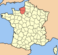
DEPARTMENTS Eure
Seine Maritime
Seine Maritime
AREA
12318Km²
The
region of Upper-Normandy is composed of the Départements of Eure [27] and
Seine-Maritime [76]. The region is bounded by the Départements of Calvados and
Orne to the west, Eure-et-Loire to the south, and Yvelines, Val d'Oise, Oise and
Somme to the east. The English Channel lies to the northwest. Haute-Normandie is
mostly lowland belonging to the Paris Basin and is drained by the River
Seine.
The Main industries are Chemical and oil, Agriculture and Tourisum.
Though Rouen is the capital and has some fine churches including Frances tallest cathedral, La Havre is the largeat city and a major Port. The other large port in the Region is Dieppe.
The Main industries are Chemical and oil, Agriculture and Tourisum.
Though Rouen is the capital and has some fine churches including Frances tallest cathedral, La Havre is the largeat city and a major Port. The other large port in the Region is Dieppe.
Capital: Rouen